
Millions Brace for Travel Disruptions from Chicago to Boston
A potentially severe ice storm is expected to cause major travel disruptions, power outages, and hazardous conditions across the Midwest and Northeast this week. According to the FOX Forecast Center, the storm will likely peak between Wednesday night and Thursday, affecting millions along the I-90 corridor from Chicago to Boston.
Winter Storm Development Raises Concerns
The storm’s development is linked to an atmospheric river system that recently impacted the West Coast with heavy rainfall and mountain snow. As this system moves eastward, it will merge with a developing low-pressure system over the Plains on Tuesday. Initially lacking moisture, the storm will gain strength as a strong southerly jet stream pulls in warm, moisture-laden air into the eastern U.S., setting the stage for a significant ice event.
This clash between warm, moist air and a shallow layer of freezing temperatures near the surface will likely result in widespread sleet and freezing rain, creating dangerous conditions for both travelers and residents.
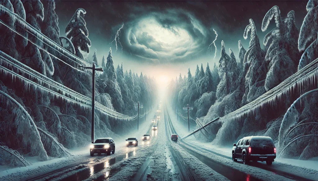
Potential Impacts of the Ice Storm
Forecasters are tracking two possible scenarios:
- Scenario One: A stronger low-pressure system dominates over the Plains, leading to widespread freezing rain from the Midwest to the Northeast. Cities such as Des Moines, Chicago, Syracuse, and Burlington could experience significant ice accumulation, increasing the risk of power outages and hazardous road conditions.FOX Weather Meteorologist Craig Herrera noted, “Unlike the usual narrow bands of freezing lines, this ice event could cover a more extensive area, posing greater risks, especially for commuters.”
- Scenario Two: A weaker low develops in the Plains, with a new coastal low forming along the East Coast. This shift would potentially spare Des Moines and Chicago from severe icing but increase the snowfall threat for areas like Syracuse and Burlington.
Expected Power Outages and Travel Hazards
Even minimal ice buildup can create dangerous conditions. Meteorologist Britta Merwin warned, “Ice accumulation between a tenth and a quarter of an inch is enough to cause power outages and major travel disruptions.”
Residents should prepare for potential power outages by gathering essential supplies, such as flashlights, batteries, non-perishable food, and water. Travel may become dangerous or impossible in severely affected areas due to icy roads, downed power lines, and fallen trees.
Cities at High Risk
Areas expected to be most affected include:
- Des Moines, Iowa: High risk of significant ice accumulation under Scenario One.
- Chicago, Illinois: Potential for heavy icing along major routes, including I-90.
- Syracuse, New York, and Burlington, Vermont: Risk of ice transitioning to heavy snow in Scenario Two.
Preparation Tips for the Ice Storm
- Power Outages: Ice as thin as 0.1 inch can down power lines. Prepare backup power sources if possible.
- Travel Safety: Expect delays or cancellations in road and air travel. Keep an emergency kit in your vehicle if travel is necessary.
- Stay Safe: Limit travel, stay indoors when possible, and keep devices charged for emergency updates.
Understanding Ice Accretion
Ice accretion occurs when freezing rain coats surfaces, forming layers of ice. This buildup adds weight that can cause tree branches and power lines to collapse. Ice accumulation over 0.25 inches significantly increases the risk of structural damage.
Stay Updated as Conditions Change
The storm’s exact path and intensity are still uncertain, with forecast models presenting different scenarios. As conditions evolve, regular updates will be provided.
For the latest information, monitor local weather reports, follow official advisories, and consider downloading the FOX Weather app for real-time updates. Enable notifications to receive critical alerts about forecast changes.
